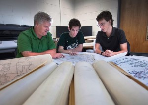
A student-faculty team is working on research to evaluate the condition of the local sewer system’s infrastructure and develop tools to help engineers run the system more efficiently.

Roger Ruggles, associate professor of civil and environmental engineering, looks over plans of Easton’s sewer system with Matthew Muller ’14 and Samuel Brinton ’14.
Led by Roger Ruggles, associate professor of civil and environmental engineering, the team is creating a computer model of the Easton Area Joint Sewer Authority’s conveyance system. The authority is made up of member municipalities of the City of Easton, Palmer Township, Forks Township, Wilson Borough, West Easton Borough, and Tatamy Borough. The model’s design will be based on inputs from the 2010 census population and will be used to analyze the conveyance capabilities of the system.
“Federal, state, and local governments have invested trillions of dollars into this infrastructure and much of it is reaching the end of its design life,” says Ruggles. “As a result, governments and their authorities are faced with maintaining and replacing this valuable resource in a time of severe budgetary restrictions. This research will supply tools for managers and engineers to both manage and design new components for the system that are economical and efficient.”
The model will allow researchers to determine sections of the system that may be at or near capacity.
“The results of the analysis can be used to compare against measured flow rates to determine potential inflow and infiltration areas within the system,” Ruggles explains. “Any future commercial or residential growth in the authority’s collection area can also be modeled to determine the impact it will have on the existing system.”
Students in Lafayette’s EXCEL Scholars undergraduate research program and civil engineering majors Matthew Muller ’14 (Glenside, Pa.), Philip Hathaway ’13 (Seneca Falls, N.Y.), and Samuel Brinton ’14 (Fairfax, Va) spent the summer speaking with officials in local municipalities to gather data to create the computer model. With their work, they have developed maps, plans, and databases, in addition to the computer model. To accomplish these tasks, the students have been using ArcMap (a geographical information system software), and AutoCAD Sanitary and Sewer System software. The students digitally scan each map, conduct on-screen digitizing, rescale information to the correct coordinate system, and input data manually.
This project is the first in a series of initiatives designed to develop a Water Resources Research Institute that will conduct research in a variety of local projects important in the field of water resources.
“Developing a computer model for the sanitary sewer network is very interesting because you get to delve into the unseen, but vital infrastructure of the city and see what’s going on down there,” says Muller. “A lot of people take sewage disposal for granted, but I now have a newfound respect for our sanitary sewer system. Sewer networks are so vital to our society’s development and expansion, so this was a valuable learning experience for me no matter what I end up doing.”
