Cara Murphy ’11
Cara Murphy ’11 (Providence, N.J.), a double major in English and psychology, is blogging about her experiences this month during a three-week course studying the evolution of life and land in Ecuador and the Galapagos Islands. The course, taught by geology professors Lawrence Malinconico and David Sunderlin and Provost Wendy Hill, is one of eight faculty-led interim-abroad classes at locations around the globe. Check back often for more updates.
January 18 – To Santa Cruz Island and Snorkeling at Tintoreras
I am sitting on the rooftop terrace at our hotel on Santa Cruz overlooking the ocean. A warm breeze envelopes me as I admire the palm trees. I wish my apartment at Lafayette had such a breathtaking ambiance!
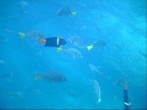
 We did an early morning snorkel at Tintoreras. Although the tide was coming in and disrupting the clarity of the water, I saw numerous colorful fish and sea turtles. Some people even saw eels and sea slugs. After lunch at a small restaurant on Isabella, we departed for Santa Cruz, the most populated island in the Galapagos. It was evident as soon as we entered the harbor that this island was more metropolitan than the others. There were large cruise ships and graffiti on the rocks along the coast. Multiple story buildings and shops decorated the main street. As we walked to our hotel we passed countless souvenir shops and restaurants (most of which had the menu in both English and Spanish- something we definitely did not experience on the other islands where I was compelled to use my limited Spanish to translate menus and ask simple questions).
I am off to study and shower before our group dinner tonight. I can’t believe today is Jan. 18. Tomorrow, we have our last day of snorkeling and ecology. On Thursday we return to Quito for our exam and then fly home on Friday. I feel so blessed to have experienced geology, biology, and culture in such a beautiful and diverse country. I wish I could stay longer to soak in the tropical sun, spectacular topography, and unique species. These three weeks have prompted me to appreciate the natural wonders of the world and inquire about how things (land, rocks, wildlife) are formed and evolved to their present state.
January 16 – Hike to Sierra Negra and Volcan Chico and Tortoise breeding center
 Today was our first full day on Isabella. The class was split into two small groups- one went snorkeling and the other hiked on the volcano.
I was in the group that hiked on volcano Sierra Negra, the second largest active caldera in the world. During the hike, we talked about the various types of vegetation that we encountered due to the water availability (which is affected by humidity and subsequent cloud cover). One of the zones was dominated by guava trees, an introduced species to the island. Introduced species are harmful for native plants in the Galapagos because they take over.
When we got close to the caldera, you could see the remnants of ‘A’ā and pahoehoe lava flows (which differ in their viscosity or how easily they flow). Words cannot articulate how this looked. We also saw lava tubes and channels. This is where the top of a lava flow cooled and hardened to produce a pipe-like structure, which provides insulation and allows the lava to travel long distances from the eruption site.
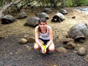
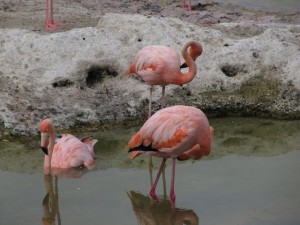
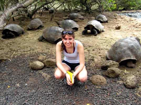
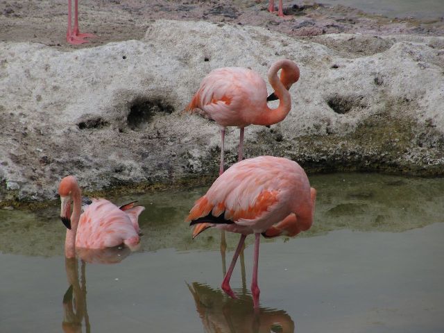
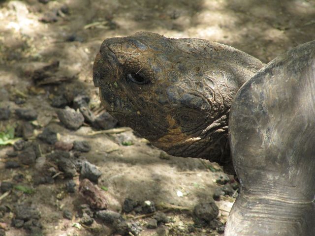
Despite my sunburn, I felt invigorated by the 10 mile hike and astonished by all of the natural wonders we saw. It was amazing to think that we could have seen flowing lava! We ended the day with a tour of Isabella’s tortoise breeding center. They separate the tortoises by age, and it is incredible to see how they develop in size from babies to 80 year olds. They are truly amazing creatures. I couldn’t help but think about what the older tortoises have seen their lifetime. On our walk back to the hotel we saw flamingos feeding on microscopic shrimp and countless iguanas. Each night, when I review my notes and prepare to write my journal I am astonished by how much we see and learn each day. This trip is truly a one in a lifetime experience!
January 15 – San Cristobal to Floreana to Isabella
 Today was another early morning-we left San Cristobal at 7 a.m. for Floreana and Isabella. Floreana is a small island to the west of San Cristobal and south of Santa Cruz. It has less than 200 inhabitants. On our two hour boat ride, we discussed the formation and evolution of the Galapagos Islands. These islands were created by a hot spot and move east along the Nazca continental plate. Thus, the youngest island is Isabella and the oldest is San Cristobal.
We snorkeled around a small tuff cone on the outskirts of Floreana. Once again, it was spectacular to be submerged in an underwater marine world. I swam with schools of fish and even saw three sharks by the sea floor. After snorkeling, we embarked on a hike on the Floreana mainland. It is interesting that the elevations on each island produce distinct habitats and climates. The coast was very dry and mostly barren. One of the only plants we saw was the cotton tree. However, as we ascended elevation, we became surrounded by green and vegetation. I felt as if I was walking in the rainforest. The land became greener because the highlands are very humid from warm air rising. We learned that many of the animal species, such as lava lizard, are only found on this island.
After we arrived at Isabella, the largest island in the archipelago, we brought our bags to our hotel. We had a group dinner with grilled swordfish, steak, soup, rice, and ice cream.
January 14 – Isla Lobos and Leon Dormido Snorkeling Sites
Today I swam with sea lions, turtles, and sharks- it was an incredible day! We met our tour guides at the pier in the morning and our snorkeling adventure began. On our way to Kicker Rock, we passed Frigatebird Hill, the alcove where Charles Darwin probably landed when he arrived at the Galapagos. Kicker Rock got its name because it looks like a shoe (or a sleeping lion- it’s still up for debate!).
 After arriving and putting on my snorkel mask and flippers, I jumped into the turquoise, crisp water. As soon as I began to swim and look down I felt as if I was swimming in an aquarium. My grandma lived in Brooklyn and I visited the New York Aquarium at least once or twice a year when I was little. Instead of pointing out vibrant, colorful fish to my mom, I was swimming amidst them!
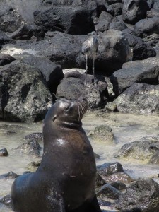
We swam close to the shore because there was abundant sea life in the shallow waters. I saw many different kinds of fish in all shapes and sizes. I was especially fascinated by the black fish with yellow fins, crabs, blue footed boobies, and of course sea lions. The blue footed boobies are excellent divers- we saw them diving for fish and resting on volcanic rock near the shore. Baby sea lions are very playful and came to swim with us. They dove above and below me and I attempted to twist and turn with them. I did not want to leave the water or my new friends!
We had the night off for dinner, and I went to a small restaurant on the boardwalk. Eating grilled fish overlooking a beach filled with sea lions was the perfect end to a picturesque day!
January 12 – Travel to the Galapagos Islands
At 7 a.m., we left Hotel Cumbaya, which has become our “home base” over the past week, to embark for the Galapagos! I can’t believe that we have been here for over 10 days. Time is flying by. I am very excited for the warm weather (I was ensured by Dr. Malinconico that I could leave my winter coat with fur hood behind in Ecuador) and ecology. We are going to see magnificent animals and incredible biodiversity.
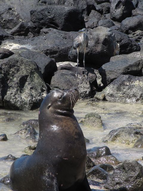
 As soon as we landed and walked into the Galapagos airport, big smiles and “oohs” and “ahhs” abounded. The weather was warm, breezy, and sunny. We left our bags at the hotel and began a short walking tour of town and the University of San Francisco’s satellite campus (GAIAS). As we meandered through town we saw many restaurants and souvenir shops. The beach was covered with sea lions, pelicans, frigate birds, and crabs. It truly felt like we were in a tropical paradise. The sea lions were very friendly and climbed up in the small boardwalk which lined the beach. They sun bathed on the patio and even climbed into the slide of a small park!
After dinner we went to salsa class at a local restaurant. Everyone caught on quickly and was spinning and grooving in no time! Due to my inability to dance, I simply watched and took pictures of everyone. I feel like I am in an oasis- not only am I learning about the origin of these magnificent islands, but also how the landscape, vegetation, and wildlife evolved!
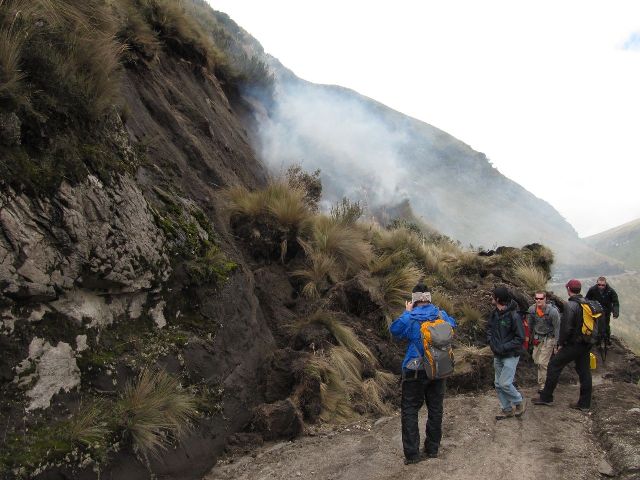
January 11 – Guagua Pichincha volcano and exam #2
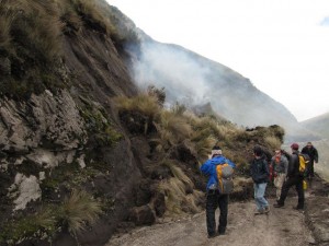 Today we visited Guagua Pichincha, a volcano right outside Quito. We began the ascent of the mountain in two small buses. We then stopped at a small village and transferred to two small jeeps and one cattle truck. I rode in the back of the cattle truck with five other students. While the ride was bumpy, we had a spectacular view of the mountain. It was as if we were sailing through the clouds. The only downside to this panoramic view was the dust we encountered- most of us looked like chimney sweepers with raccoon eyes from our sunglasses by the end.
Unfortunately, we encountered a landslide which inhibited us from reaching the planned hiking path. We investigated the landslide, which was a slump or dry avalanche. We concluded it occurred around two weeks ago due to accumulated moisture and over-steepened slopes created by the man-made road. Over the past week, I have seen how humans have influenced, and in many cases, ravaged the natural environment. The road exacerbated the naturally wet soil and caused the landslide of material.
On our journey back to Hotel Cumbaya, we made a few stops to examine geologic features. We saw a large loess deposit that resembled a sand dune. Loess is dust and small particles that crumble when you rub them between your fingers. It was transported by a glacier to the base of Guagua Pichincha. We also saw noded horse tail plants, which contain phytoliths (silicate, glassy shards in the stem) to prevent animals from eating them. Indigenous people have used this plant for cleaning because its texture resembles that of a Brillo pad. It is so interesting to learn about the various adaptations that plants have acquired to improve their chance of survival. I have always considered plants to be pretty passive and subject to their environment. But plants such as the noded horse tail and species we encountered in the paramos of the Andes have exhibited adaptations which enable them to battle a harsh climate and altitude.
When we arrived back at the hotel, I showered and studied for our second exam of the course. After the exam, I went to a little Italian restaurant around the corner from the hotel and began packing my duffel with warm weather clothes for the Galapagos! I can’t wait for sunshine and warm weather!
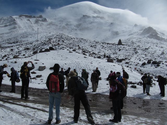
January 9 – Chimborazo and Tungurahua Volcanoes
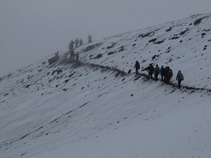
After a cold night in the village (I slept with four layers on!), we had breakfast and departed for Chimborazo. When we started the hike, we were at 15,400 ft. The day was sunny, but many people were having trouble breathing at such high altitude. We discussed the phenomenon of adiabatic lapse rate (the difference in air temperature depending on moisture content in the air) as we attempted to traverse a peak. We climbed to about 16,200 ft., but the snow was too deep to cross. We attempted to go around another way, but got caught in a storm. Winds were whirling and hail pelted our faces. Due to the conditions, we were forced to retrace our steps and return to the refuge. We then had lunch at a charming restaurant at the foot of Chimborazo. We removed our wet hiking boots and wore comfy slippers. Photographs of the mountain and hiking gear adorned the walls. The warmth of the fire and beauty of the landscape were a welcomed relief.
 After lunch, we continued our trip south to the town of Banos, which lies at the base of Tungurahua, a recently active volcano. We had dinner at the hotel and celebrated Sean and Bob’s birthdays with tiramisu. Then, we had an hour to walk and explore the city. Even though it was late, there were a number of stores open. We browsed through handmade souvenirs, including scarves, jewelry, and trinkets. We also sat in a quaint park with a water fountain. As we gazed up at Tungurahua, we saw what looked like floating crosses. We realized that these were lights hung upon houses on the side of Tungurahua. It was picturesque and a wonderful end to an arduous day.
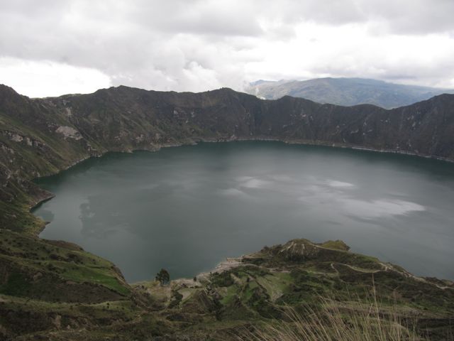
January 8 – Quilotoa Lake and Achignan Village
Today, we embarked south of Quito. On the bus we caught up on readings and much needed sleep. It was difficult to concentrate on the readings, however, because all I wanted to do was stare out the window. The faces of the local people, magnitude of the mountains and volcanoes, and vibrancy of the vegetation tell a captivating story of the history and culture of Ecuador.
We spent four hours passing verdant green valleys and mountains. Despite the steep slopes, the local people have built houses in order to utilize the fertile soils for farming (as evidenced by the over 30 types of potatoes grown in Ecuador) and animal grazing. We passed cows, llamas, and sheep. The bus even needed to yield for sheep crossing!
 Our first stop was at an indigenous market in zumbahua. Men, women, and children were selling alpaca scarves, jackets, hats, and gloves. Vibrant colors caught my eye, and I could not resist buying gloves and a jacket for myself and souvenirs for my family and friends. Little children were carrying chickens, fruit, and vegetables to the numerous crude stands to sell and prepare meals. We certainly stood out amidst the crowd of people. Many of the Ecuadorians were small, and I found myself the same height or taller than most of the women and men (and I am only 5’4”, so you can imagine the guys on the trip must have been perceived as giants!).
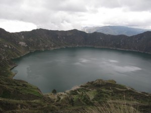
After lunch we walked around Quilotoa Lake. This lake is called a caldera and was created by the collapse of a magma chamber within a volcano (once the volcano erupted most of the material in it, the surface rock caved in because there was nothing to support it).
We arrived for a late dinner at the village of Achignan. The people were very hospitable and even staged a welcome ceremony for us. The leader of the village introduced the community and told us a little bit about their daily lives. A few children of the village sang some traditional songs and danced. Then, they invited us to dance with them! I don’t know whose smile was bigger- mine or that of the children as we were clapping to the beat and dancing to the rhythms of the song. After the children were done, the women who cooked our meal came out of the kitchen and sang a few songs accompanied by guitar.
Today opened my eyes and heart to the indigenous people of Ecuador. These people gave us all of their energy, time, and resources. The two little girls who danced in the welcoming ceremony were not wearing shoes- while I had two layers of pants, a long sleeve shirt, sweatshirt, and jacket on. I feel so blessed to have the opportunity to be on this interim trip and I know that the things I learn- both in and out of my field notebook- will be with me for the rest of my life.
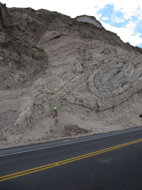
January 7 – Metamorphic Core and Deformation
Today, we made three geologic stops on our way back to our original hotel in Quito from the hot springs. In the morning, we investigated a stream which flowed from atop the Cayambe Coca Reserve that we hiked yesterday. We saw metamorphic rocks, which have various degrees of color and mineral banding due to the type of stresses or pressures they encountered after forming. On the next stop, we saw a large lake and used the surrounding topography and types of rocks found there to hypothesize that it was formed by a landside.
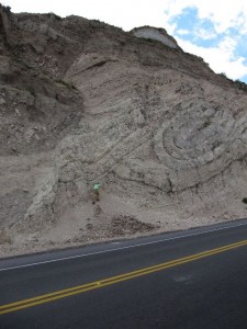 Our last stop for the day was directly on the equator. We saw a large rock outcrop with gigantic swirls and waves in it. It looked like a masterpiece of sculpted rock. I learned that the forces that created this were folding (bending) and faulting (breaking) of the rock due to compression pressures. When I first saw it I was in awe of its enormity and intricacy. However, it wasn’t until after I discovered how it was formed that I realized the impressive power of geologic pressures. As humans, we are often astounded by man-made edifices and enthralled with our technology. But we are at the mercy of these formidable geologic forces which have dictated where we can build and inhabit. We have been compelled to adapt to the topography of the Earth- not the other way around.
For dinner we were allowed to explore the area around our hotel in a suburb of Quito. I went to a small restaurant around the corner from the hotel with a small group of people. When we arrived, I tried to speak Spanish, but the owner quickly recognized that we were American and explained the menu to us in English. I ordered blackberry juice (blended fresh in the kitchen upon order) and ceviche, an Ecuadorian specialty consisting of shrimp in a cold soup that resembles a salsa. The meal was delicious and we went to a local paneria or bakery for ice cream bars and cookies for dessert.
January 6 – Papallacta Hike
- 12-kilometer hike through the Cayambe Coca Reserve, glacial striations, and hot springs–a typical day in the Ecuadorian Andes
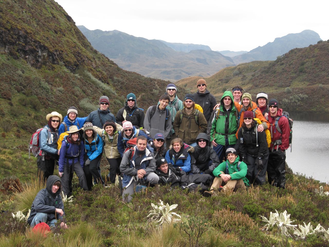
 Our day began with a hike through the Cayambe Coca Reserve. We started at 14,200-feet above sea level and descended through various paramos (different types of ecosystems occurring in the Andean Highlands). There are many species that are endemic (or restricted) to this region. The descent through the paramos was indicated by different plant types and the removal of layers of clothing (we began the hike bundled in winter coats, gloves, and hats, and ended in t-shirts and even shorts).
The superparamo consisted of the highest elevation and lowest oxygen level. This is a harsh climate and plants developed various adaptations in order to survive here. The lopini is a purple flower that contains ribosomes in its roots. These ribosomes help to produce nitrogen which is lacking in the atmosphere at such a high elevation.
The next paramo we encountered was the proper paramo and then the grass paramo. Here, we saw the ballerina flower, which is white and used by the natives as a tranquilizer. We also saw “rabbit ears” which were covered in hairs as soft as a blanket. These hairs protected the plant from harsh temperatures. The last paramo on our hike was the subparamo or the lower limit.
After a four and a half hour hike, most of us were tired and a bit sore. Needless to say we were ecstatic when we arrived at a hot springs resort at the base of the mountain. The girls stayed in one beautiful cabin with two floors (while the boys divided into three cabins of five or six). As soon as we stepped off the bus and got our keys we rushed to put on our bathing suits. There were three spring pools based on temperature. Most people stayed in the medium temperature, but I ventured with some brave souls into the hottest pool. Sliding into the steaming water with the mountains in the background was therapeutic and picturesque.
I can’t believe we have accomplished so much in only one day. We have only been here for four full days and yet I have already seen fantastic sights and learned about how geologic pressures can form these massive beauties. It is incredible how these forces have created the landscape which we see today.
January 5 – Cotopaxi Volcano
- Hike to the base of the glaciers on Cotopaxi, through fresh snow fall. Examine lava flow, spatter, and ash stratigraphy.
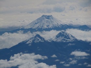
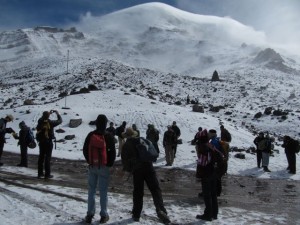
Words cannot describe the incredible physical landform I saw today. The videos and pictures Dr. Malinconico and Dr. Sunderlin showed us in the weeks leading up to this trip did not come close to capturing the awe and massive beauty of the Cotopaxi volcano. Cotopaxi is an active volcano and probably the most feared and famous in Ecuador (though it is not the most dangerous).
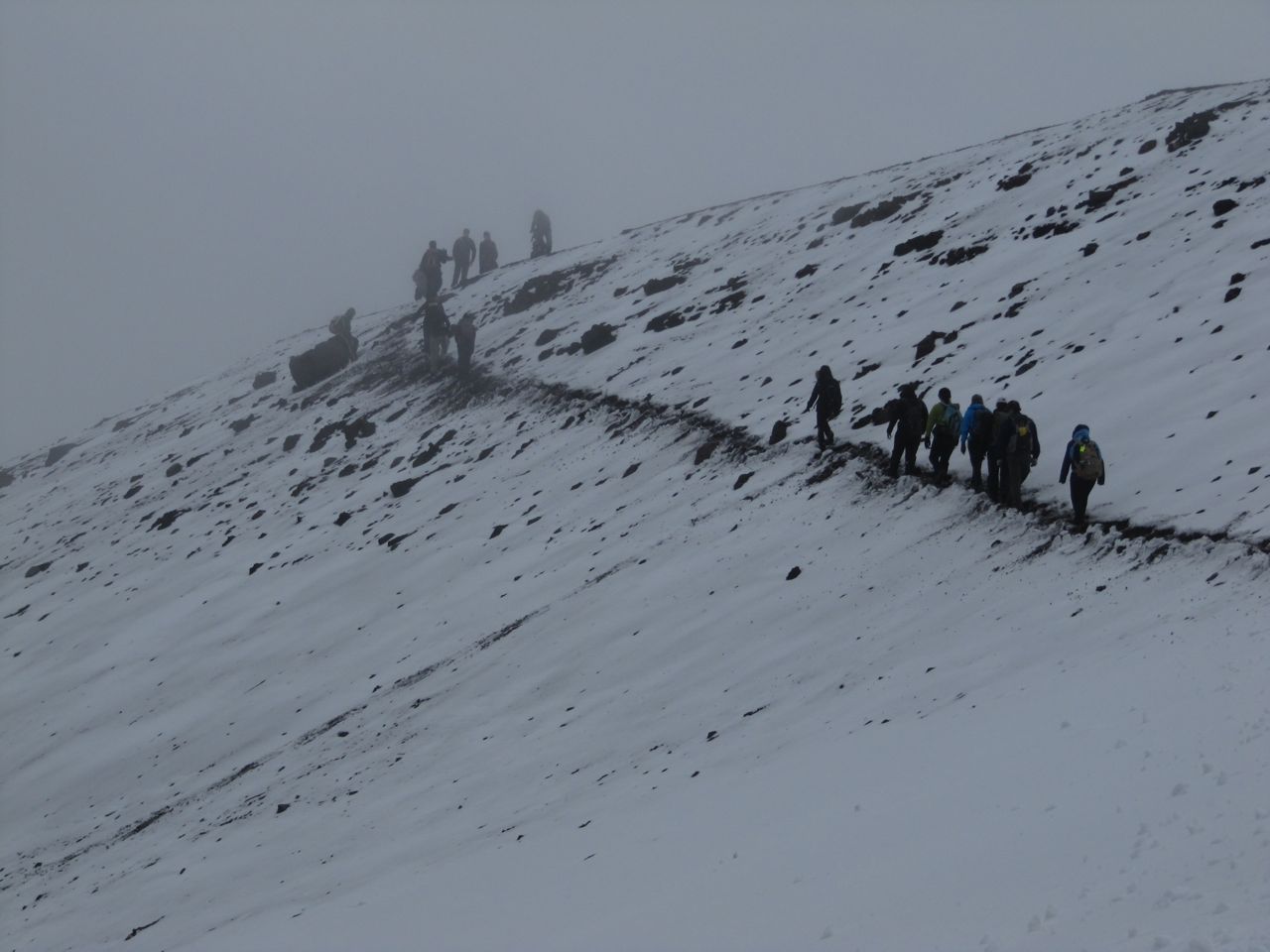
 We left our hotel in Quito at 8 a.m. and got to Cotopaxi by 11:30 a.m. We drove to the snow line at 14,000 feet to start our ascent hike. The hike was a little over a mile through volcanic ash deposits (loose little pebbles) at a very steep incline. After 50 steps my heart began to race. I stopped along with the group three or four times to catch my breath and regain my footing. From the base of the mountain, I assumed the white cap of the mountain was composed entirely of snow. However, the ground upon which we were hiking was filled with bead-size hail pellets. These were especially slippery and I was afraid of sliding back down the mountain!
Three-fourths of the way to our destination an Ecuadorian man passed us. He was carrying a metal container filled with gas for the rest stop above. While we felt winded and tired, he was an incredible exhibition of lung capacity and strength!
We stopped at the rest stop (15,800-feet above sea level!) to eat lunch and talk about the geologic processes that created Cotopaxi. Cotopaxi is a stratovolcano, which means that it was built up by successive deposits from volcanic eruptions. On our descent we investigated rocks left behind by a lava flow. Some were large and dark in color (andesite or basalt porphyry, which resulted from thick, slow-moving lava flows), while others were more porous and red in color. These red rocks were easily broken and weathered due to their large surface area and probably created by vents close by rather than the main orifice atop Cotopaxi.
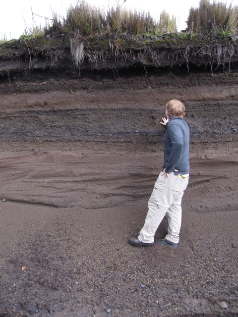
 As we walked back to the bus, we also examined exposed sediment deposits in the soil. From this, we could estimate the number of volcanic flows based on the density and differences between layers. Although these rocks told a vivid story of the destructive capability of Cotopaxi, the landscape also indicated the restorative and constructive consequence of volcanic eruptions. The mafic ash present in volcanic debris contains minerals that act as a fertilizer. There were many crops growing and animals grazing in the valleys below the volcanic peak.
For dinner, we had an authentic Ecuadorian meal at a small restaurant right outside Cotopaxi. Every time I became engrossed in a conversation or my meal I would simply look up and see the massive snow-covered peak before me, reminding me I was in Ecuador visiting spectacular volcanic sites!
January 4 – Orientation and Quito City Tour
Today, we woke up early and had breakfast in the hotel. The fresh fruit juice and bread were delicious. Next, we went to the Universidad San Francisco de Quito. We learned about the Galapagos Academic Institute for the Arts and Sciences, the first liberal arts institute in Ecuador. We listened to lectures about Andean history, culture, and volcanic activity. It was incredible to see pictures of volcanoes that we are going to visit, such as Cotopaxi, the most feared volcano in Ecuador.
We then went into the historic center of Quito. The city square is surrounded by four important buildings, including the cathedral and presidential palace.
We meandered through an open air market and walked into a Panama hat shop. Though called Panama hats, they are actually made in Ecuador from the plaited leaves of the toquilla straw plant. Each hat is made by hand, evidenced by the skilled craftsmanship.
We also walked into the Church of the Society of Jesus of Quito. It was breathtaking–every square inch was filled with gold-painted decorative wood sculptures and religious paintings. In 1987, an earthquake hit Quito and the church was not restored until 2002.
Our last stop before dinner was the city museum. We traced the history of Ecuador from indigenous times to the Incan empire, Spanish conquest, and modern times. We saw ancient tools, recreations of traditional huts, and Spanish dress.
Dinner was a four-course meal at a wonderful restaurant. I especially enjoyed the cheesecake with berry filling.
January 3 – Travel Day
- Travel from Easton, Pa., to Quito, Ecuador – 16 hours door-to-door!
 We left Easton early this morning and flew from Newark to Houston and then from Houston to Quito. It was a long day of travel. We occupied ourselves with class readings (about volcanoes, their destruction, and types of deposits left after an eruption), listening to iPods, and trying to find comfortable positions to sleep. (I was not as successful as some of my classmates at this endeavor.)
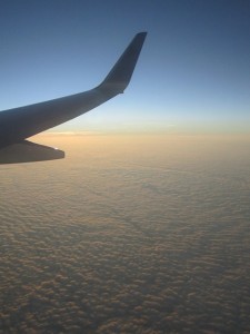
I was lucky enough to have a window seat on the flight from Houston to Quito. It was cloudy in Houston, but soon after takeoff we ascended above the clouds. It was as if we were flying over a sea of clouds bathed in sunlight.
When we arrived in Quito, it was after 11 o’clock. From the plane, we could see a city lit up with lights. We traveled back to the hotel and ascended the stairs with our bags. I have not experienced any altitude side effects yet, but then again we are not at the highest elevation that we will ascend during this trip (which will be in the Andes). I’m off to get some rest before our tour of the local university and city tomorrow.
Pre-trip Observations
It’s four days before we leave for Ecuador and the Galapagos Islands. Time is flying by! I’m busy trying to pack and visit with family and friends before I head back to Lafayette on Jan. 1. I’m filled with so many different emotions. I am excited to explore the diverse landscapes, people, and wildlife in Ecuador but also nervous to be in a foreign country (a country that lies over 9,000 feet above sea level!). I have never taken a geology course nor embarked on any extensive hiking. But I am certainly up for an adventure and ready to go on a once in a lifetime trip!


1 Comment
Comments are closed.